Title:
Map of Oakland and Alameda [cartographic material] / Woodward & Taggart, Agents
for the purchase, sale and appraisal and care of real estate ; M G. King, surveyor.
Creator:
Brown, Grafton Tyler, 1841-1918.
Subject:
Real property - California - Oakland - Maps.
Land titles - California - Oakland -
Maps
Description:
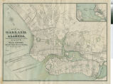
Scale : ca. 1:24000. Title from item. Lithographic map of Oakland and Alameda,
showing block numbers, ownership of large parcels, railroads, charter line and proposed areas
for reclamation; inset map at upper right corner of San Francisco Bay, showing proposed
reclamation. Oriented with north toward upper left. Lithography by "G. T. Brown and
Co., 540 Clay St., San Francisco". On bottom: "Entered according to an Act
of Congress in the year 1877, by M. G. King, in the office of the Librarian of Congress at
Washington, D.C.". Based on surveys made by M. G. King, C. E. In upper right corner :
175. The carto-lithographer, Grafton T. Brown, was an early African-American settler in West
Oakland.
Publisher:
Oakland Public Library
Contributor:
Brown, Grafton Tyler, 1841-1918 ; King, M. G.
Date:
1877
Type:
image
Format:
1 map : col., ink on paper ; 45 x 52 cm.
Identifier:
copl_071
Language:
eng
Coverage:
Oakland (Calif.) - Maps; Alameda (Calif.) - Maps
Rights:
public domain
Material is in the public domain. No restrictions on use.