Title:
Plat of the Town of San Antonio, California [cartographic material] / surveyed by J.E.
Freeman.
Creator:
Freeman, J. E.
Subject:
Historical maps - California - Oakland.
Historical maps - California - Alameda
County.
Abell, Alex A.
Stevens, T. H.
Humbert, A.
Larue, James B.
Joseph S. Friedman
Frank, Isaac
Lazard, S.
Jacobs, S. L.
Jacobi, Simon
Description:
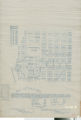
Scale not given. Title derived from item. Copy of a map filed September 12th, 1854
as "recorded at request of James B. Larue, April 27th 1869 at 30 minutes past 1.00
P.M.". Block map of the town of San Antonio, showing streams emptying into San
Antonio Creek and the boundary with the town of Clinton "beginning [from] the East
corner of a house at the South West corner of Arroyo and Washington Street." Portions
of the map were "taken from a previous survey by C. C. Tracy, Esq., also a U. S.
Deputy Surveyor." In bottom right corner: "33A 1". In bottom left
corner: "1/3". Digitized from an official copy made from the original
resource on file with the Alameda County Recorder.
Publisher:
Oakland Public Library
Contributor:
Tracy, C. C. ; Alameda County (Calif). Clerk Recorder.
Date:
1869
Type:
image
Format:
1 map : col., ink on vellum ; 64 x 44 cm.
Identifier:
copl_072
Source:
Official maps of Alameda County. Alameda County Recorder.
Language:
eng
Coverage:
San Antonio (Calif.) - Maps. ; East Oakland (Calif.) - History - Maps.
Rights:
public domain
Material is in the public domain. No restrictions on use.