Title:
Gateway District Entry Aerial
Creator/Contributor:
Jamieson, Doug E., Illustrator
Date:
circa February 2009
Historical Note
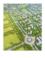
This hand painted rendering depicts UC Merced’s Gateway District looking north at full development. It was part of an eight
piece set developed to capture the design and planning intentions embodied in UC Merced’s 2009 Long Range Development Plan.
The Gateway District includes the area between the Bellevue Road roundabout south, (featuring an iconic tower feature), to
the Cardella Road roundabout at the bottom of the image. The two roundabouts are linked by an extension of the planned Campus
Parkway connected to Highway 99, the San Joaquin Valley’s major transportation corridor. Lake Road is depicted to the left
of the Campus Parkway with a cul-de-sac on its north end. Only the northern part of the district is part of the actual campus,
and would include academic buildings oriented towards research. The southern portion is envisioned as a zone for public or
private research and development.
The dominant feature of the image is a curved main spine, the Crescent that gives the Gateway District a more urbanized character
than the rest of the campus. The Crescent is shown here as taking on the character of a boulevard with formal street trees
on either side of the road and along the planted median. The shape and orientation is intentionally similar to the smaller
arch on the western edge of the University of California, Berkeley campus with a slight nod to the Champs-Elysees in Paris,
France. In the land use plan, the top of the Crescent includes a regional transit center serving both the campus and the
research and development parks.
To create a defined canopy, planners envisioned street trees spaced no less than 25 feet and no more than 30 feet apart, aligning
across the road from one another. The perimeter street trees are depicted along a continuous landscape median strip and carry
through to the pedestrian plazas that anchor the north and south ends of the Crescent. During the planning process, planners
envisioned that the understory be used to reflect sustainability issues of the landscape, perhaps with opportunities for non-native
species, drought tolerant shrubs, groundcover or perennials.
Medium:
watercolor
Language:
English
Copyright Note:
Copyrighted by University of California Merced, Physical Planning Design and Construction Archives. Transmission or reproduction
of materials protected by copyright beyond that allowed by fair use requires the written permission of the copyright owners.
Works not in the public domain cannot be commercially exploited without permission of the copyright owner. Responsibility
for any use rests exclusively with the user. For permissions to publish contact the University of California Merced, Physical
Planning Design and Construction Archives.