Title:
Official map of the City of Oakland [cartographic material].
Creator:
Whitcher, J. E. (Jeremiah E.).
Subject:
Real property - California - Oakland - Maps.
Illustrated maps - California - Oakland.
Description:
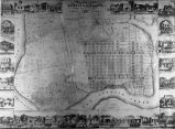
Title from container. From the Joseph R. Knowland collection at the Oakland History
Room, Oakland Public Library. Photograph is a reproduction of a city map produced by Jeremiah
E. Whitcher. The map is bordered with illustrations of local structures prominent to Oakland
at the time; described (clockwise, from upper right corner), as follows: J. A. Hobart, Daniel
Smith [sign drawn to read "Oakland Bakery"], Capt. Michelsen's wharf,
Charles Blaise [sign on structure reads: "Bellevue du Rendez-vous de
Chasse," although the corner Number in collection : 304.
Publisher:
Oakland Public Library
Contributor:
Drouaillet, Gustave. ltg
Date:
1860
Type:
image
Format:
1 photograph : negative. b&w ; 10 x 13 cm.
Identifier:
copl_063
Knowland Neg. 304
Language:
eng
Coverage:
Oakland (Calif.) - Maps - 1860. ; Oakland (Calif.) - Industries - Pictorial works. ;
Oakland (Calif.) - Buildings, structures, etc. - Pictorial works.
Rights:
public domain
Material is in the public domain. No restrictions on use.
1860