Title:
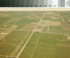
Aerial photograph of Geer Road and Monte Vista intersection in Turlock, California, circa 1969.
Creator:
Dias, Manuel, 1918-2005
Subject:
Cities and towns -- Pictorial works
Land use -- California -- Turlock
California State University, Stanislaus
Stanislaus State College
Description:
The oval track on the campus of Stanislaus State College, circa 1969, is visible to the left of the photograph. The school's
name changed in 1972 and again in 1985 when it gained university status. Geer Road runs parallel to the track and intersects
with Monte Vista Avenue where one of Turlock's first shopping centers is located. Predominately farmland surrounded the college
in 1969.
Publisher:
California State University, Stanislaus. University Library. Special Collections
Date:
circa 1969
Type:
image
Format:
1 photographic print; 9 x 13 cm.
Identifier:
cturs_192
Language:
eng
Coverage:
Turlock (Calif.) -- Aerial photographs
Rights:
copyrighted
Transmission or reproduction of materials protected by copyright beyond that allowed by fair use requires the written permission
of the copyright owners. In addition, the reproduction of some materials may be restricted by terms of gift or purchase agreements,
donor restrictions, privacy and publicity rights, licensing and trademarks. Works not in the public domain cannot be commercially
exploited without permission of the copyright owner. Responsibility for any use rests exclusively with the user.
Dias, Manuel, 1918-2005
Consult owning institution.
circa 1969