Title:
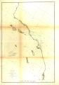
U. S. Coast Survey / Benjamin Pierce superintendent ; sketch J. showing the progress of the survey in section no. x (lower
sheet) from San Diego to Pt. Sal.
Creator:
United States Coast Survey
Subject:
United States -- Surveys
Maps
Triangulation
Surveying
Description:
Map illustrates the progress of the coastal survey through the use of occupied and unoccupied stations to triangulate positions
along the coast from 1850 to 1871.
Publisher:
Coronado Public Library
Date:
1871
Type:
Image
Format:
1 map : hand col. ; 56 x 79 cm.
Identifier:
ccoron_158
Language:
eng
Relation:
https://coronadolibrary.org/
Coverage:
California, Southern
Rights:
Public domain
Material in the public domain. No restrictions on use.