Title:
Aerial View of Anaheim, Including Disneyland. [graphic]
[Digital Anaheim.]
Creator/Contributor:
Geotronics, Aerial Photography,, Long Beach, Calif.
Abstract:
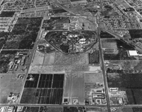
Aerial View of Anaheim, showing area from Vermont Street to Katella Ave. and between Harbor Blvd. and Walnut Street; image
shows the I-5 freeway at top, right and Disneyland in the center of the photograph; hotels and motels are visible along Katella,
Harbor and Walnut, as well as the disappearing orange groves.
Date:
June 7, 1958 (issued)
Subject:
Anaheim Resort Project Area
--
California --
Anaheim.
Land use --
California.
Municipal engineering
Recreation --
1900-Present.
Streets --
California --
Anaheim.
Amusement parks --
California.
Santa Ana Freeway --
California
Disneyland (Calif.)
Note:
Accession number: P843
Ink stamped on back with "Aerial Photography / GEOTRONICS / 725 E. THIRD ST HEmlock 5-8326 / LONG BEACH, CALIF. 90812."
Type:
Aerial views
Photographic print
Physical Description:
1 Photographic print: b&w; 8 x 10 in.
Related Item: