Title:
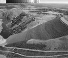
Aerial view of the new Don Pedro Dam's back side prior to its coverage by reservoir water.
Creator:
Dias, Manuel, 1918-2005
Subject:
Dams -- California
Reservoirs -- California
Description:
Depicted is the back side of the earth-rock structure of the new Don Pedro Dam, sited on the Tuolumne River in the Sierra
Nevada Mountains northeast of Turlock, California. On the top of its 580 foot rise, construction of a highway take place.
To the right of the road, the face of the dam slopes downward. The new dam is 296 feet higher than the old Don Pedro that
can be seen with its ports open spilling water. A new reservoir will cover the back side of the new Don Pedro Dam and the
old dam.
Publisher:
California State University, Stanislaus. University Library. Special Collections
Date:
1970 November 2
Type:
image
Format:
1 photographic print; 21 x 26 cm.
Identifier:
cturs_198
Language:
eng
Coverage:
Don Pedro Dam (Calif.) -- Aerial photographs; Sierra Nevada (Calif. and Nev.); Tuolumne River (Calif.); Turlock (Calif.)
Rights:
copyrighted
Transmission or reproduction of materials protected by copyright beyond that allowed by fair use requires the written permission
of the copyright owners. In addition, the reproduction of some materials may be restricted by terms of gift or purchase agreements,
donor restrictions, privacy and publicity rights, licensing and trademarks. Works not in the public domain cannot be commercially
exploited without permission of the copyright owner. Responsibility for any use rests exclusively with the user.
Dias, Manuel, 1918-2005
Consult owning institution.
1970