Title:
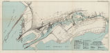
Port facilities at Oakland and Alameda, Cal. [cartographic material] / War Deparment,
Corps of Engineers, U.S. Army.
Creator:
United States. Army. Corps of Engineers.
Subject:
Harbors - California - Oakland - Maps.
Harbors - California - Alameda - Maps.
Marine terminals - California - Oakland - Maps.
Port of Oakland - Maps.
Description:
"November 1938". "Data by R.C.T.; Drawn by
D.D.A." Scale : ca. 1:19000. Reverse transfer line print. Map of Alameda and the
Oakland waterfront from the Bay Bridge to terminal to San Leandro Bay, showing port facilities
(cargo terminals by product, administrative buildings, warehouses, raw materials processing
facilities, shipbuilding and repair facilities, ferries, drydocks) and major thoroughfares.
Publisher:
Oakland Public Library
Contributor:
United States. Board of Engineers for Rivers and Harbors.
Date:
1938
Type:
image
Format:
1 map : col. ; 35 x 70 cm.
Identifier:
copl_199
Language:
eng
Coverage:
Oakland (Calif.) - Harbor - Maps. ; Alameda (Calif.) - Maps.
Rights:
public domain
Material is in the public domain. No restrictions on use.