Title:
Map of part of Napa County known as Nicolas Higuera's Tract : [part of Rancho Entre Napa, Calif.] / Surveyed by Loring, U.S.
Deputy Surveyor
Creator/Contributor:
United States. District Court (California : Northern District). Land case. 176, Related Name Indexing Term
Abstract:
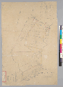
Includes index to deeds and owners.Cadastral map.From: U.S. District Court. California, Northern District. Land case 176 ND,
page 92; land case map E-394 (Bancroft Library). Joseph Mount et al., clmt.Pen-and-ink and watercolor.4362 E6"Filed in office
July 7, 1854."
Date:
1853
Subject:
Rancho Entre Napa (Calif.) -- Maps, Manuscript
United States--California (1853)
Physical Description:
1 ms. map : col. ; on sheet 73 x 49 cm.
Scale [1:15,840]. 4 in. [to] a mi.
Language:
English
Local Call Number:
Land Case Map E-394
Copyright Note:
Some materials in these collections may be protected by the U.S. Copyright Law (Title 17, U.S.C.). In addition, the reproduction
of some materials may be restricted by terms of University of California gift or purchase agreements, donor restrictions,
privacy and publicity rights, licensing and trademarks. Transmission or reproduction of materials protected by copyright beyond
that allowed by fair use requires the written permission of the copyright owners. Works not in the public domain cannot be
commercially exploited without permission of the copyright owner. Responsibility for any use rests exclusively with the user.
Copyright Owner Note: All requests to reproduce, publish, quote from, or otherwise use collection materials must be submitted in writing to the
Head of Public Services, The Bancroft Library, University of California, Berkeley 94720-6000. Consent is given on behalf of
The Bancroft Library as the owner of the physical items and does not constitute permission from the copyright owner. Such
permission must be obtained from the copyright owner. See: http://bancroft.berkeley.edu/reference/permissions.html