Title:
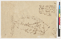
El citio qe. se solicita llamada Acalanes : qe sealla entre el Aroyo de Galindo, y Aroyo Grande, tentrá de latitud, de sur
`a norte, una leg[u]a, poco mas `o menos, y de longitud, de oriente `a poniente, segun el cuadro, poco mas omenos, tres cuartos
de legua
Creator/Contributor:
United States. District Court (California : Northern District). Land case. 31, Related Name Indexing Term
Abstract:
From: U.S. District Court (California). Land case 31 N.D., p. 32; Elam Brown, claimant.Oriented with north toward left.Pen-and-ink
and pencil.4362 A16
Date:
[185-?]
Subject:
Contra Costa County (Calif.) -- Maps -- 1834
Contra Costa County (Calif.) -- Maps, Manuscript
Rancho Acalanes (Calif.) -- Maps, Manuscript
Physical Description:
1 ms. map ; on sheet 22 x 32 cm.
Scale [ca. 1:225,000] (W 122°23'--W 122°06'N 37°58'--N 37°52')
Language:
Spanish
Local Call Number:
Land Case Map A-65
Copyright Note:
Some materials in these collections may be protected by the U.S. Copyright Law (Title 17, U.S.C.). In addition, the reproduction
of some materials may be restricted by terms of University of California gift or purchase agreements, donor restrictions,
privacy and publicity rights, licensing and trademarks. Transmission or reproduction of materials protected by copyright beyond
that allowed by fair use requires the written permission of the copyright owners. Works not in the public domain cannot be
commercially exploited without permission of the copyright owner. Responsibility for any use rests exclusively with the user.
Copyright Owner Note: All requests to reproduce, publish, quote from, or otherwise use collection materials must be submitted in writing to the
Head of Public Services, The Bancroft Library, University of California, Berkeley 94720-6000. Consent is given on behalf of
The Bancroft Library as the owner of the physical items and does not constitute permission from the copyright owner. Such
permission must be obtained from the copyright owner. See: http://bancroft.berkeley.edu/reference/permissions.html