Title:
Plan of the Rancho San Ysabel : [San Diego County, Calif.] / surveyed for Dn. José Joaqn. Ortega by W.H. Leighton, Acting
Coy. Surveyr., San Diego County
Creator/Contributor:
Leighton, W. H. (William H.), author
Creator/Contributor:
United States. District Court (California : Southern District). Land case. 191, Related Name Indexing Term
Abstract:
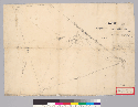
Pen-and-ink.From: U.S. District Court. California, Southern District. Land case 191 SD, page 108; land case map E-1209 (Bancroft
Library)."Surveyed June 15th, 1856 ... "Shows drainage, roads, boundaries, distances, etc.Relief shown by hachures.4362 S3913
Date:
1856
Subject:
Rancho Santa Ysabel (San Diego County, Calif.) -- Maps, Manuscript
Physical Description:
1 ms. map ; on sheet 49 x 68 cm.
Scale [1:31,680]. 1/2 mile to an in. (W 116°43'/N 33°09').
Language:
English
Local Call Number:
Land Case Map E-1209
Copyright Note:
Some materials in these collections may be protected by the U.S. Copyright Law (Title 17, U.S.C.). In addition, the reproduction
of some materials may be restricted by terms of University of California gift or purchase agreements, donor restrictions,
privacy and publicity rights, licensing and trademarks. Transmission or reproduction of materials protected by copyright beyond
that allowed by fair use requires the written permission of the copyright owners. Works not in the public domain cannot be
commercially exploited without permission of the copyright owner. Responsibility for any use rests exclusively with the user.
Copyright Owner Note: All requests to reproduce, publish, quote from, or otherwise use collection materials must be submitted in writing to the
Head of Public Services, The Bancroft Library, University of California, Berkeley 94720-6000. Consent is given on behalf of
The Bancroft Library as the owner of the physical items and does not constitute permission from the copyright owner. Such
permission must be obtained from the copyright owner. See: http://bancroft.berkeley.edu/reference/permissions.html