Title:
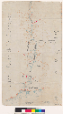
[Map of old and new fences along Cojo Creek between Rancho Punta de la Concepcion and Rancho Nuestra Señora del Refugio :
Calif.]
Creator/Contributor:
Unknown, Author
Date:
[189-?]
Subject:
Rancho Punta de la Concepcion (Calif.)--Maps, Manuscript
Rancho Nuestra Señora del Refugio (Calif.)--Maps, Manuscript
[ca. 1:7,400] (W 120?34?--W 120?11?/N 34?35?--N 34?30?).
Note:
Relief shown by contours
Shows drainage, survey markers, corral, water holes, whaling station, road, etc
Pen-and-ink on tracing cloth
Scale [ca. 1:7,400] (W 120?34?--W 120?11?/N 34?35?--N 34?30?)
Type:
Maps
Physical Description:
ms. map : col. ; on sheet 34 x 20 cm
Language:
English
Local Call Number:
Map G 04362 P82 1890 M3 Case A Bancroft
Filename:
cubanc_1_2_00008373a.tif
Copyright Note:
Copyright status unknown. Some materials in these collections may be protected by the U.S. Copyright Law (Title 17, U.X.C.).
In addition, the reproduction of some materials may be restricted by terms of University of California gift or purchase agreements,
donor restrictions, privacy and publicity rights, licensing and trademarks. Transmission or reproduction of materials protected
by copyright beyond that allowed by fair use requires the written permission of copyright owners. Works not in the public
domain cannot be commercially exploited without permission of the copyright owner. Responsibility for any use rests exclusively
with the user.
Copyright Owner Note: All requests to reproduce, publish, quote from, or otherwise use collection materials must be submitted in writing to the
Head of Access Services, The Bancroft Library, University of California, Berkeley 94720-6000. Consent is given on behalf of
The Bancroft Library as the owner of the physical items and does not constitute permission from the copyright owner. Such
permission must be obtained from the copyright owner. See: http://bancroft.berkeley.edu/reference/permissions.html