Title:
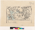
[Map of the San Francisco Bay Area, Calif. : showing location of the Rancho de los Meganos]
Creator/Contributor:
Unknown, Author
Date:
1872?
Subject:
San Francisco Bay Area (Calif.)--Maps
Rancho Los Meganos (Calif.)--Maps
San Francisco Bay Area (Calif.)--Maps--1872
[1:760,320]. 12 miles to an in. (W 122?40?--W 121?10?/N 38?20?--N 37?40?).
Note:
Relief shown by hachures and spot heights
Shows drainage, completed and projected railroads, etc
Covers San Francisco and portions of Marin, Sonoma, Solano, Sacramento, San Joaquin,Alameda, and Contra Costa Counties
Scale [1:760,320]. 12 miles to an in. (W 122?40?--W 121?10?/N 38?20?--N 37?40?)
Type:
Maps
Physical Description:
1 map : col. ; 10 x 17 cm
Language:
English
Local Call Number:
Map G 04362 S22 1872 M3 Case A Bancroft
Filename:
cubanc_1_2_00007830a.tif
Origin:
[California? : s.n., 1872?]
Copyright Note:
Copyright status unknown. Some materials in these collections may be protected by the U.S. Copyright Law (Title 17, U.X.C.).
In addition, the reproduction of some materials may be restricted by terms of University of California gift or purchase agreements,
donor restrictions, privacy and publicity rights, licensing and trademarks. Transmission or reproduction of materials protected
by copyright beyond that allowed by fair use requires the written permission of copyright owners. Works not in the public
domain cannot be commercially exploited without permission of the copyright owner. Responsibility for any use rests exclusively
with the user.
Copyright Owner Note: All requests to reproduce, publish, quote from, or otherwise use collection materials must be submitted in writing to the
Head of Access Services, The Bancroft Library, University of California, Berkeley 94720-6000. Consent is given on behalf of
The Bancroft Library as the owner of the physical items and does not constitute permission from the copyright owner. Such
permission must be obtained from the copyright owner. See: http://bancroft.berkeley.edu/reference/permissions.html