Title:
North Bowl
Creator/Contributor:
Jamieson, Doug E., Illustrator
Date:
circa May 2009
Historical Note
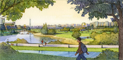
This hand drawn and painted aerial rendering is a southwest view through campus from the end of the North Bowl. It was part
of an eight piece set developed to capture the design and planning intentions embodied in UC Merced’s 2009 Long Range Development
Plan. It was used as the cover image for the 2009 Long Range Development Plan publication.
On the right, the Sierra View and North View student neighborhoods overlook the North Bowl’s recreation fields. The tower
in the far distance marks intersection of Bellevue Road and Lake Road, a prominent location for a potential landmark. The
rendering depicts familiar elements of the campus’ design vocabulary: lantern-like entrances, place-making bridges over the
canals and multiuse open space that can accommodate storm-water and recreation.
The North Bowl, like the related South Bowl, provides an open space focus for buildings within the core of the campus.
Medium:
watercolor
Language:
English
Copyright Note:
Copyrighted by University of California Merced, Physical Planning Design and Construction Archives. Transmission or reproduction
of materials protected by copyright beyond that allowed by fair use requires the written permission of the copyright owners.
Works not in the public domain cannot be commercially exploited without permission of the copyright owner. Responsibility
for any use rests exclusively with the user. For permissions to publish contact the University of California Merced, Physical
Planning Design and Construction Archives.